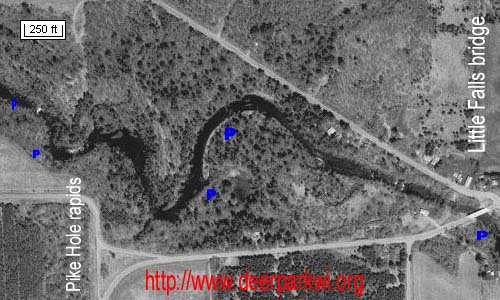
The Pike Hole Rapids, Apple
River, Little Falls, Wisconsin
Shown on September 8, 2002.
The stream makes a sudden drop of about 8 feet into a small gorge known locally
as the Pike Hole, a portion of the water's fall is pictured here. Skin divers
say the falls feature an underwater cave and a dangerous undertow during high
water.
The Apple River is a popular fast-flowing river in Northwestern Wisconsin
and is most famous for inner tubing fun in the Somerset area. But far upstream
near Little Falls, Wisconsin the Apple comes alive during periods of heavy
precipitation.
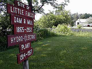
At the bridge the stream begins a sudden decline and the thrills begin at
the old foundation of the Little Falls dam and power plant which washed out in
1957.
Listen to the Apple
Digital Stereo Recording
A clickable map, five photos near the blue
P's are available.
The satellite view shows the stream flowing from the Little Falls bridge,
right to left.
A
good place to start an Apple River adventure is below Black Brook Dam (45°15.825' 092°24.174')
at the nearby park. Some danger areas to check before hand are at the Little
Falls Bridge (45°16.410' 092°25.092') and the Pike Hole rapids (45°16.484'
092°25.692') water fall area for protruding rocks at low water levels. A good
indicator of water flow is at the dam itself. No water flowing over the
spillway and water from only one generator tunnel means very low water. If you
see many rocks in mid-river at the Little Falls bridge, come back another time.
For a calmer transit of the river, try the Alden Township high bridge
(45°16.785' 092°28.306') (3 miles downstream from Little Falls) to highway 65
or beyond. The highway 65 landing is on the right bank about 425 feet upstream
from the bridge at (45°16.757 092°28.290).
The river is ever changing on a daily basis, is not
monitored and parts are blocked with trees. Canoers, kayakers, rafters, and
tubers will be isolated in many areas. Roads parallel the river on the left
side to the Alden High Bridge within 1/2 mile.
Kayakers should have their skirts on by the Little Falls bridge. Rapids in the
Pike Hole area are estimated at class 2 - 3, the deepest portion is on the
right half. The shelf below has a calm area along the right bank, with high
water the left half is fine and there is a huge boulder mid-stream exposed
during low water. Click on the map to view the lower rapids photo to see the
shelf.
You can exit the river before the Pike Hole rapids on the left side of the
river after passing a rock cliff about 20 feet high.
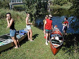
A party from
Milltown, Wisconsin gets ready
to canoe from the Alden Township High Bridge.
Near the area of a mansion with large chimneys on the left bank, the river
splits. (45°16.605' 092°26.705') The old shallow channel to the right is
calmer with trees you might have to portage around. The new main channel may or
may not be clear of trees. Other trees beyond nearly block the river. After
Wapogasset
Branch, a quiet stream, the river is deeper with a peaceful finish to the Alden
High Bridge.
This is September 2002 information, none of it is
guaranteed as changes constantly take place.
"To the lost man, to the pioneer penetrating a new country, to
the naturalist who wishes to see the wild land at its wildest, the advice is
always the same -- follow a river. The river is the original forest highway. It
is nature's own Wilderness Road." -Edwin Way Teale
"Although it was wonderful to see all that water tumbling down, it would be
even more wonderful to see all that water tumbling up." -Mark Twain
 A
good place to start an Apple River adventure is below
A
good place to start an Apple River adventure is below